
Geographic Information:
Maps have been used for thousands of years, but it is only within the last few decades that the technology has existed to combine maps with computer graphics and databases to create geographic information systems or GIS.
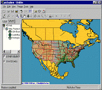
GIS is used to display and analyze spatial data which are tied to a relational database. This connection is what gives GIS its power: maps can be drawn from the database and data can be referenced from the maps. When a database is updated, the associated map can be dynamically updated as well. GIS databases include a wide variety of information: geographic, social, political, environmental, and demographic.
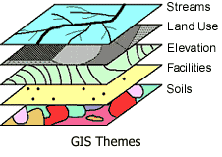
GIS uses layers, called "themes" to overlay different types of information, much as some static maps use Mylar overlays to add tiers of information to a geographic background. Each theme represents a category of information, such as roads or forest cover. As with the old mylar maps, the layers which are underneath remain visible while additional themes are placed above.
Services:
ESS combines orthorectified satellite images and digital aerial photography mosaics with extracted vector and client supplied attribute data and hot links, using ESRI’s ArcView GIS, ArcGIS and ArcGIS 3D Analyst Project files, in support of GIS Based Products:
Web-based GIS and GIS/Mapping solutions
Conversion of Hard Copy Information to Digital Files - Digitization
Spatial data integration and geo-database design
Seamless GIS database creation
Power Distribution system
Gas & Petroleum pipelines
Corridor mapping
Land cover classification
Urban development
Environmental monitoring
Coastal erosion studies
Property and Tax mapping
Raster to Vector Translation:
To complement the mapping functions included in GIS and other Mapping and Data processing software, vector data is utilized to facilitate the visualization of surface and subsurface features. To assure that the vector data, to be extracted from Digital Satellite Images, Aerial Photo mosaics or digital map data, is free of any Coordinate ambiguities outside of the Project specifications, all Satellite Image data and Digital Aerial Photography is orthorectified.
Topographic, Geological or any other type of source maps are rectified, utilizing at least 75-100% of the available grid ticks on the maps.
Final vector data can be provided in a variety of formats, like AutoCAD DWG or DXF, ESRI Shape files, standard ASCII X, Y, Z or Client requested format and referenced to specified Survey Datum and Mapping Projection.